News From Traffic Congestion to Sustainable Mobility: Rethinking India's Urban Transportation Systems
How population growth, architectural design, traffic engineering, government policies and intelligent infrastructure can help create safer, more accessible and climate-responsive Indian cities.
Introduction: India's Growing Cities Need Smarter Mobility
India's rapid urbanisation is increasing demand for housing, employment, transportation and public infrastructure. According to the World Bank's 2025 data, India's urban population is estimated at approximately 522.4 million. This is an estimate based on United Nations population data and national definitions of urban areas, not a census count. The UN's World Urbanization Prospects 2025 provides further estimates and projections through 2050.
However, transport infrastructure has not developed uniformly with urban growth. Cities such as Bengaluru, Pune, Mumbai and Delhi face significant congestion, while expanding cities such as Lucknow and Ranchi need proactive mobility planning.
Urban transportation is not simply about moving vehicles; it is about connecting people to workplaces, schools, healthcare and public spaces. Sustainable mobility therefore requires coordination between architecture, land use, population density, road engineering and environmental planning.
Population Growth and the Cost of Traffic Congestion
Urban expansion, longer commuting distances and increasing dependence on private vehicles place pressure on existing roads. The TomTom Traffic Index 2025 highlights congestion levels in major Indian cities.
|
City |
Congestion level |
Annual rush-hour time lost |
|
Bengaluru |
74.4% |
168 hours |
|
Pune |
71.1% |
152 hours |
|
Mumbai |
63.2% |
126 hours |
|
New Delhi |
60.2% |
104 hours |
These percentages are TomTom's congestion-level indicators, not the proportion of vehicles delayed. Annual time lost represents estimated additional rush-hour travel time.
Road safety is another major concern. The Ministry of Road Transport and Highways recorded 480,583 road accidents and 172,890 fatalities in 2023. Congestion, unsafe street design and inadequate pedestrian facilities are interconnected mobility and public-health challenges.
Architecture and Urban Planning: Designing Around People
Transportation planning should begin alongside land-use and building design. The location of housing, offices, schools, commercial areas and public facilities influences travel distances and transport choices.
Five principles can support sustainable urban development:
Population density and mixed land use can support regular public transport demand when homes, workplaces, shops and community facilities are well connected. However, density alone does not guarantee sustainable mobility. It must be supported by adequate transport services, pedestrian infrastructure and essential utilities.
Architects should coordinate building entrances, parking, service access, drop-off areas and pedestrian circulation with surrounding streets from the master-planning stage.
Indian Example: Chennai's Complete Streets Approach
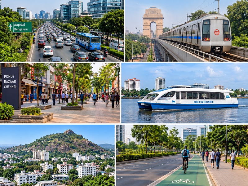
Chennai demonstrates how street design can prioritise people. The Pondy Bazaar pedestrian plaza in T. Nagar transformed approximately 700 metres of commercial street through wider walking areas, seating, landscaping, children's play spaces and public amenities. Chennai's wider street-transformation programme has also focused on continuous footpaths, safer crossings, cycle infrastructure and street connectivity.
For Ranchi, similar principles could improve markets, educational areas, institutional campuses and neighbourhood streets, subject to local travel surveys and available road space.
Traffic Engineering, Safety and Indian Standards
Safer mobility requires appropriate road hierarchy, intersection design, visibility, pedestrian crossings, traffic signals and speed management. These measures are particularly important near schools, markets, residential areas and public institutions.
Relevant Indian guidelines include:
The Motor Vehicles Act, 1988, particularly Section 112, provides the legal framework for speed limits. Applying these standards through suitable street design, road-safety audits and enforcement can reduce risks for vulnerable road users.
Government Policies and Implementation
India's urban transport framework includes the National Urban Transport Policy (2006), Metro Rail Policy (2017), National Transit Oriented Development Policy (2017), Smart Cities Mission and PM-eBus Sewa.
The official PM-eBus Sewa dashboard reported the following status on 13 October 2026:
Sanctioned, deployed and operational figures represent different stages of implementation. Actual benefits depend on route planning, depots, charging facilities, accessible stops, service frequency and last-mile connectivity.
Effective implementation requires coordination among governments, urban local bodies, transport agencies and traffic authorities, supported by funding, maintenance and measurable performance targets.
Smart Technologies and Sustainable Transport
Technology can improve transport planning and traffic operations when supported by reliable infrastructure.
Emerging automated transport concepts should undergo independent feasibility, safety, cost and accessibility assessments. They should complement—not replace—essential investments in buses, metro systems, walking and cycling.
Indian Examples and the Ranchi Opportunity
Indian cities demonstrate different approaches to sustainable mobility. Ahmedabad's Janmarg BRTS illustrates dedicated bus corridors, while Delhi Metro demonstrates high-capacity urban rail supported by feeder and last-mile services. Kochi Water Metro connects island communities through electric-hybrid ferries and accessible terminals integrated with the metro network. The Government of India's Economic Survey 2025–26 reports that its cumulative ridership crossed five million passengers during 2025.
Ranchi: Planning for Future Mobility
Census data recorded 1,073,427 residents within the Ranchi Municipal Corporation area in 2011, compared with 847,093 in 2001—an increase of approximately 26.7%. These are historical municipal-boundary figures, not current population estimates.
ITDP's Mobility for All: A Strategic Transportation Plan for Ranchi (2015) identified dependence on private vehicles and paratransit and recommended stronger bus services, walking and cycling facilities, and parking management. As this study is historical, its recommendations should be reassessed through updated household travel surveys, origin-destination studies, traffic counts and road-safety audits.
Ranchi can improve connections between residential neighbourhoods, institutional areas, commercial centres and future transport corridors by considering pedestrian movement, public transport access, junction safety, street vending, parking demand and accessibility for people with disabilities.
Parking Management and Road-Space Planning
Unmanaged parking can obstruct footpaths, reduce road capacity and make walking unsafe. Cities can improve parking management through designated on-street and off-street spaces, appropriate charges, time restrictions, enforcement and integration with public transport.
Road widening and flyovers may be necessary in specific locations, but they are not universal solutions. Additional road capacity can attract more vehicle trips over time, limiting long-term congestion benefits. Before widening roads, authorities should assess public transport, junction redesign, pedestrian safety, cycling facilities, parking management and the movement of essential goods and emergency vehicles.
The Way Forward: People-Centred Urban Mobility
India's cities need integrated action across planning, design, engineering and governance. Key priorities include:
Architects, urban planners, transport engineers, developers and public authorities must work together to ensure that infrastructure investments deliver long-term public value.
ABIRIBA LIMITED: Connecting Architecture, Infrastructure and Sustainable Development
At ABIRIBA LIMITED, we recognise that sustainable urban development depends on integrating architecture, infrastructure and responsible planning. Our multidisciplinary expertise connects Architecture, Engineering, Urban and Landscape Design, Interior Design, and Technology and Research.
The planning of streets, public spaces, institutional campuses, commercial developments and residential neighbourhoods influences accessibility, travel patterns, pedestrian safety and the overall urban experience. Through context-driven design, coordinated engineering and landscape integration, we aim to support functional and future-ready built environments.
Explore related ABIRIBA publications:
Our approach supports the broader vision of “Designing Better Spaces, Shaping Sustainable Futures.”
Conclusion: Moving Towards a Sustainable Urban Future
Traffic congestion reflects how cities are planned, designed and developed. Building more roads without improving public transport, land-use planning, parking management and pedestrian infrastructure offers limited relief.
The future of urban mobility lies in connecting architecture with infrastructure, integrating transportation with land-use planning and placing people at the centre of development. For cities such as Bengaluru, Delhi, Pune, Lucknow and Ranchi, sustainable mobility must become an essential part of urban master planning.
The objective should not simply be to move more vehicles, but to help more people reach their destinations safely, efficiently and sustainably.
References and Government Guidelines
Data note: Population and mobility figures refer to their stated reporting years. The World Bank's 2025 urban population figure is an estimate based on UN population data, not a census count. Ranchi Census figures are from 2001 and 2011, and the ITDP study was published in 2015. PM-eBus Sewa figures are an official dashboard snapshot dated 13 October 2026. Kochi Water Metro ridership refers to cumulative passengers reported during 2025.